Record of meeting 20th June 2024
Present: J.B., A.C., M.L., D.M.
Ringinglow Ramble Part I
For this summer solstice evening’s meeting we explored aspects of Ringinglow. AC has written four pieces about Ringinglow which are available on the FHG website – see reference list at end of these notes. The area has been known/recorded as ‘Ringin Lowe, Ringing Lawe’ and ‘Ringinglowe’, (see Harvey, 2001 for etymology and Crutch, 2023 for ancient historical background). Until around the early 20th century, this was an industrial as well as farming area. It included quarries, mines, a wire mill and Copperas House.
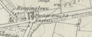
1855 (click on image for link to map) Reproduced with the permission of the National Library of Scotland https://maps.nls.uk/
1898 Reproduced with the permission of the National Library of Scotland https://maps.nls.uk/
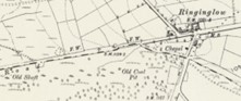
1924 (click on image for link to map) Reproduced with the permission of the National Library of Scotland https://maps.nls.uk/
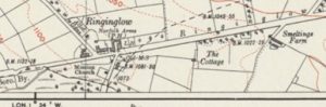
1947 (click on image for link to map) Reproduced with the permission of the National Library of Scotland https://maps.nls.uk/→
- We met at the layby opposite the Norfolk Arms; tractors were passing frequently between Sheephill Road and Hangram Lane as they transported hay – a process which had been going on from early that morning. Go back a hundred or so years and this would have been a similar scene on a dry June evening, but with horses pulling the hay wagons: Hall, 1974 contains photos of early twentieth century haymaking at Bole Hill Farm land and Brown Hills Field
- We looked for evidence (e.g. boundary walls, types of vegetation) of the Weigh House which used to stand at this corner (Crutch 2023)
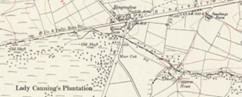
- We also considered the evidence of mining and source of the Limb Brook in Lady Canning’s Plantation and the ‘Ring of Firs’ a little further west from the Ringinglow cross roads (see Hall 1974 and Crutch 2023)
Firs and bulge in wall 1855 and present
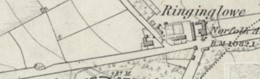

1855 map reproduced with the permission of the National Library of Scotland https://maps.nls.uk/
4. We then walked round the corner onto Sheephill Road and crossed the stile into Barberfields to look at evidence of coal mining, the remains of Copperas House and other features: DM pointed out the spoil heap and referred us to FoPV report August 2006; AC shared maps and information; there are remains rail tracks but we didn’t explore that far
We discussed roads and tracks in the area:
- important links between Derbyshire, Cheshire, Manchester and Sheffield
- transportation of goods such as lead (Smeltings Farm nearby)
- the evidence of Roman roads, the Houndkirk Road, Ringinglow as a turnpike road, how roads developed and became more or less significant (see Hall & Blackwell, 1972 pp 20-21 and Crutch 2023)
5. We retraced our steps over the stile and considered the buildings edging Sheephill Road
- Moor Cottage – formerly Moorcot/Moorcott- which was built on the site of Moorcock Hall in 1911, according to Hall, 1974, p. 38
- The Mission – formerly Ringinglow Church (Crutch 2023 and pages 39-40 of Hall 1974)
- The Round House (Crutch 2023 and Hall & Blackwell 1972, pp 20-21)
- The ‘low’ suffix of Ringinglow indicates a large pile of stones which could have been a barrow (Harvey, 2001); Crutch, (2023), suggests a site for these stones could lie somewhere between the present day Moor Cottage and The Norfolk Arms
6. We crossed Ringinglow Road and looked at evidence of the former wire mill; a resident of the cottage kindly showed us the outbuildings where the milling took place (see Crutch 2023)
We noticed the signs carved into the kerbstones on the corner of Ringinglow Road and Fulwood
7. Walking east past the Norfolk Arms, there is a Victorian wall letter box and by the car park exit there is the milestone CITY OF SHEFFIELD 5 MILES TO TOWN HALL; the reference to city dates the stone as post 1893; perhaps it replaced an earlier milestone which stood here when Ringinglow Road was a turnpike (1758 – 1825)
8. Next meeting/walk 18th July – meet at Ringinglow layby 7pm for Ringinglow Ramble Part II
References
Crutch, A. (2023) Four Posts Giving a brief history of Ringinglow. Fulwood History Group. https://www.fulwoodhistory.uk/author/alan/
- Ringinglow Early Years
- Buildings of Ringinglow: The Chapel, The Round House and The Norfolk Arms, ‘T’ Ring o’ Firs’
- People
- Industry
Friends of the Porter Valley. (2006). Mining and Quarrying in the Porter Valley – Delving Into the Past. Friends of the Porter Valley. https://www.fopv.org.uk/product-page/mining-and-quarrying-in-the-porter-valley-delving-into-the-past
Hall, M. and Blackwell, R. (1972). The Mayfield Valley. Mail Graphic
Hall, M. (1974). More of the Mayfield Valley with Old Fulwood. J. W. Northend Ltd
Harvey, P. (2001). Street Names of Sheffield; The stories behind Sheffield’s street names. Sheaf Publishing.